
úterý 10. prosince 2019
pondělí 8. ledna 2018


středa 3. ledna 2018
Přelet nad letištěm

Krásně zaparkované letadla na letišti:

Havaroval jsem na letišti C zabraným nepřátelskými vojsky, ale zadní střelci nedokázali střílet.


středa 27. prosince 2017
Scouting suggestion
This suggestion includes some improvements which would make the RB or possibly SB air battles more interesting. This improvement should bring more realistic and interesting experience for bomber pilots. The suggestions here are complex and each other depended.
This topic is about:
1) making bases more complex and detailed
2) adding a bonus: free scout aircraft for bomber pilots
3) adding spawn point for this scout aircrafts
4) using this scout aircraft to get retro photos of the bases and plans of the destination
5) return to the nearest airfield and obtain the photos and plans for the bombers
6) view the photos or plans
Illustrative photo (Plan of attack)
DETAILS
1) COMPLEX BASES
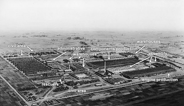
Developers could create complex bases of various types. E.g. Factory for production of engines for aircrafts. Such base would include Halls of production, warehouses with components and final products, civil area with houses for workers. Possibly train station.
The size of the base would be various depending on the tier of bombers. Every building would be valued so when a bomber destroys it, he will get some points. The more important the building is, the more points it will get. However if he would destroy civil houses, some points would be reduced.
If the bases would stay as simple as possible, then the scout aircraft would be useless. Only the complexity of the bases and its variability make use of the scout, photos and planes of the attack.
More sophisticated base.
2) BONUS: SCOUT AIRCRAFT
A free aircraft for scouting purposes would be ready for every player who has a bomber. So he would take this aircraft in the case that he wants to make photos of the target area to make bombing more precise.
- The count of scouts would be limited to count of the enemy bases. So if enemy has 4 bases, only 4 scouting missions are allowed total. So if my team has 4 scouts in game, I cannot use the scout anymore.
- For lower tiers some biplane like Falco or Freccia could be great, but the plane should not have any guns. Another nice aircraft could be Swordfish, but instead gunner, there could be a photographer.
- I would prefer to use cockpit view to make photos. It looks better. I would prefer to force player to play in cockpit, at least when he gets close to the base.
- If the scout is killed, the bomber pilot still can start to use his bomber.
3) ADDING SPAWN POINT for scouts
If the pilot would select to scout some base, the the server would select location to scout. There would be as many spawn points as there are the enemy bases on the map. The location where the scout would be spawned could be about 3-5km from the enemy base. This means, they would be spawned in air at speed about 200-250 kmh. The altitude would be 1000m AGL.
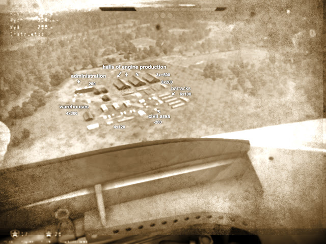
4) CAPTURING PHOTOS
From a cockpit view, he could create captures. The captures should not complain any markers or score bars.
- The photos could be viewed when the plane lands on airfield.
- Retro photos would be generated. No markers, no score bar, no radar dish.
To view all images (retro photos) please click this link.
I suggest to create the retro photo based on the tier of the plane. If it is I-II it could be like this:
If it is higher rank it could contain colors like this:
5) GETTING PHOTOS AND PLANS
Now when the player landed, the photos and plans would be prepared in the retro manner. The base objects would be described on the planes, and points for kill of the objects.
6) VIEWING
Bomber pilots could get the photos and plans for the base already scouted. When they would view a map, then icon would be present over the base. When they click on the icon, then they would view the photos or plans of that base.

ANOTHER IDEAS:
There could be Repair and Build area on the base. If this area is not destroyed, the Factory could be rebuild. The rebuild process would be slow. It would slowly increase the score for the team, which base was bombed. It would be great to find the Repair or Builders area to kill them.
BENEFITS
Bomber pilots would need to make accurate bombing which should be more interesting and more realistic. It may not be so easy to destroy the base completely. It would take longer. If you would fly in tier I, the base would be small, base it you would fly in tier III-IV, the base could be larger and more sophisticated.
A scout plane simply adds more time to play. You can not to kill with it, but you can crash enemy aircraft. Adding more time for bomber players (in scout plane) is good because bombers are very vulnerable and they usually have shorter life than fighters.
A bomber pilot can decide whether to scout destination base.
If he succeeded to get the photos to airfield, he would get some points.
He still has a choice not to use the scout aircraft, but his disadvantage is that he may hit civil buildings which reduces his score or he will not hit the main buildings.
The bomber pilots could view the attack plans during the flight to the base. They usually have a lot of time so they can check details.
You can think that the scout aircraft
This topic is about:
1) making bases more complex and detailed
2) adding a bonus: free scout aircraft for bomber pilots
3) adding spawn point for this scout aircrafts
4) using this scout aircraft to get retro photos of the bases and plans of the destination
5) return to the nearest airfield and obtain the photos and plans for the bombers
6) view the photos or plans
Illustrative photo (Plan of attack)
DETAILS
1) COMPLEX BASES
Developers could create complex bases of various types. E.g. Factory for production of engines for aircrafts. Such base would include Halls of production, warehouses with components and final products, civil area with houses for workers. Possibly train station.
The size of the base would be various depending on the tier of bombers. Every building would be valued so when a bomber destroys it, he will get some points. The more important the building is, the more points it will get. However if he would destroy civil houses, some points would be reduced.
If the bases would stay as simple as possible, then the scout aircraft would be useless. Only the complexity of the bases and its variability make use of the scout, photos and planes of the attack.
More sophisticated base.
2) BONUS: SCOUT AIRCRAFT
A free aircraft for scouting purposes would be ready for every player who has a bomber. So he would take this aircraft in the case that he wants to make photos of the target area to make bombing more precise.
- The count of scouts would be limited to count of the enemy bases. So if enemy has 4 bases, only 4 scouting missions are allowed total. So if my team has 4 scouts in game, I cannot use the scout anymore.
- For lower tiers some biplane like Falco or Freccia could be great, but the plane should not have any guns. Another nice aircraft could be Swordfish, but instead gunner, there could be a photographer.
- I would prefer to use cockpit view to make photos. It looks better. I would prefer to force player to play in cockpit, at least when he gets close to the base.
- If the scout is killed, the bomber pilot still can start to use his bomber.
3) ADDING SPAWN POINT for scouts
If the pilot would select to scout some base, the the server would select location to scout. There would be as many spawn points as there are the enemy bases on the map. The location where the scout would be spawned could be about 3-5km from the enemy base. This means, they would be spawned in air at speed about 200-250 kmh. The altitude would be 1000m AGL.
4) CAPTURING PHOTOS
From a cockpit view, he could create captures. The captures should not complain any markers or score bars.
- The photos could be viewed when the plane lands on airfield.
- Retro photos would be generated. No markers, no score bar, no radar dish.
To view all images (retro photos) please click this link.
I suggest to create the retro photo based on the tier of the plane. If it is I-II it could be like this:
If it is higher rank it could contain colors like this:
5) GETTING PHOTOS AND PLANS
Now when the player landed, the photos and plans would be prepared in the retro manner. The base objects would be described on the planes, and points for kill of the objects.
6) VIEWING
Bomber pilots could get the photos and plans for the base already scouted. When they would view a map, then icon would be present over the base. When they click on the icon, then they would view the photos or plans of that base.

ANOTHER IDEAS:
There could be Repair and Build area on the base. If this area is not destroyed, the Factory could be rebuild. The rebuild process would be slow. It would slowly increase the score for the team, which base was bombed. It would be great to find the Repair or Builders area to kill them.
BENEFITS
Bomber pilots would need to make accurate bombing which should be more interesting and more realistic. It may not be so easy to destroy the base completely. It would take longer. If you would fly in tier I, the base would be small, base it you would fly in tier III-IV, the base could be larger and more sophisticated.
A scout plane simply adds more time to play. You can not to kill with it, but you can crash enemy aircraft. Adding more time for bomber players (in scout plane) is good because bombers are very vulnerable and they usually have shorter life than fighters.
A bomber pilot can decide whether to scout destination base.
If he succeeded to get the photos to airfield, he would get some points.
He still has a choice not to use the scout aircraft, but his disadvantage is that he may hit civil buildings which reduces his score or he will not hit the main buildings.
The bomber pilots could view the attack plans during the flight to the base. They usually have a lot of time so they can check details.
You can think that the scout aircraft


čtvrtek 9. listopadu 2017

neděle 16. července 2017
Thermal stream solution
Introduction
Instead of creating and placing arrows to describe thermal stream as suggested in general suggestion about Winds and Thermal flow I suggest new way - using thermal planes. To place arrows would be too hard and slow


In the text bellow I suggest to create work space which would be box or cube. This work space would be a group of horizontal planes used to describe thermal stream. Last of all, there will be wind descriptors, which would be the vertical planes.

This suggestion describes the idea of thermal planes, wind planes and how to automate the job that it could be auto-created by program. Also I suggest to create edit tool, which would enable to made small modifications like rotation of the planes or change it's values.
Description of the generation of thermal planes
First of all a tool would be needed to calculate surfaces parallel to sea level.
To give you an idea, I have created mesh terrain in Sketchup. Then I have created 24x24m face/plane parallel to x/z axis. From the face I have created a cube (I just duplicated the top of the cube and move it down). The blue cube is space cca 24x24x25m (width x depth x height). This is space where I want to create faces which should be parallel to the map plane.

To give you idea I have added yak added into the cube.

What I need to do now is to hide or delete the faces, because this only limits the space for the job.
Now when we have the edges only (Perspective View):

I will draw small faces into the cube to give you idea what I am going to do.
I start drawing the face with 3m offset from left edge. The resulting face has 8x24m.

 Now I need more faces like this. I duplicate the faces with 5m offset.

Now I need to duplicated the faces again, but in depth axis direction:

Almost done. Now I need to create Black and white texture (one byte channel). The texture will be defined by shadows direction and other factors which the creator of thermal streams should specify.
To give you idea, I set sun position to 7/18th 17:30 (UTC-7:00) and turn shadows on.

Now you see that the planes are covered with the shadows. The shadow must be projected to the plane to generate texture. The only problem is that every plane needs to have individual texture. You would be able to calculate the shadow and create a texture for the surface, but the creator of thermal streams can need to adjust the texture later.
The texture will accept these rules:
Value:
0-125 - air flows downwards (y-axis down)
126-127 - no stream up nor down
128-254 air flows upwards (y-axis up)
Note that the value does not mean temperature but a speed of the air stream.
Hence when you would create black or dark gray lines for shadows then this is right the air streams downwards because it is warm. When you would create white light gray lines for shadows then this is right the air flows upwards because it is hot
You could calculate how heavy or how warm the air is depending on air temperature and height of the terrain. There is more factors of the terrain what could have effect on the value of the shadow or light.
The size of the texture in this example is 8x24px where 1px is 1m in the 3D space.
Now I edited texture of terrain and textures of the two planes in the cube.

So you see the texture which where the shadow of the mountain is projected. Once again, this should be made automatically by program. This was 1st plane from top.
Now the second plane from top:

Because when I turn off the textures and turn on the shadows you can see this:

Another planes (3th):

Notice that the borders of my texture are not perfect... There are mistakes but this doesn't mind.
Next plane all all back because they are completely in shadow. I would skip editing so far, but there could be gentle differences in the intensity of the shadow pixels.
When the program would generate these textures we have something like this:

Explanation
These values should indicate intensity of the air stream in the area.
Dark means the air goes down.
Light means the air goes up.
Further adjustments of the textures
Another adjustment and calculations are needed.

We need to find out how far is the side of the hill, by other words what is the distance between the horizontal plane and the mesh 1) in the same level 2) 2,5 above the plane 3) 2,5 bellow the plane. This will give us an idea about the direction of the thermal stream. This can be later used to rotate the plane.
Now we can apply this rule:
The air goes down slowly if it is close to the steep mesh terrain (mountain).
The air goes up faster if it is far away from the steep mesh terrain (mountain).
This will result in a gradient texture.

All these steps should be made by program will we get these textures which we can edit manually.
How the thermal stream would work

When the aircraft will fly through these planes which should be invisible, the wings will fly via the B/W pixels. In the place where the wing meets the pixel it works like indicator of current stream.
Intensity of the planes and resolution
In this example I used very dense planes. It is not needed to be so dense. In this particular case it would be enough if there would be only one plate in the top instead of two. The resolution here is 8x24, but I think smaller resolution like 3x8 could be enough.
There are spaces between the planes because it is not needed to collect the information "continuously". The gap between planes is 4m so the selected resolution could be 1px=4m.
These planes should be around the mountains and hills.
Vertical planes
Think about vertical planes to measure horizontal speed and direction of wind.

Manual editor of the textures
Manual editor to manipulate with the boxes or with the planes would be useful. The creator or the thermal stream should edit the textures if he needs to improve the stream to be more exact. Basic tools like rotate or move would be helpful. Also a possibility to select texture, scale it or position it would be useful. Also consider separate the thermal textures to neutral: average value 126-127, calm: average value 0-125 and warm: average value 128-254 to make simple orientation in the textures.
Every plane would have a texture. But if the textures are similar, no need to use unique texture. There are just gentle differences in the values.
Dynamical planes
It should be possible to adjust all the planes automatically to create suitable textures for every season or various extreme temperatures. The main organisation for thermal textures could be like this:
Hard Winter Textures: a) night b) morning c) noon d) afternoon e) evening
Ease Winter Textures: a) night b) morning c) noon d) afternoon e) evening
Spring Textures: a) night b) morning c) noon d) afternoon e) evening
Hard Summer Textures: a) night b) morning c) noon d) afternoon e) evening
Ease Summer Textures: a) night b) morning c) noon d) afternoon e) evening
Autumn Textures: a) night b) morning c) noon d) afternoon e) evening
* Easy / Hard - describes normal vs extreme conditions
When a map would load it would load the appropriate textures + modify them depending on current air temperature. I admit loading dynamical change of weather would be harder because at least 3 sets/scenarios of textures would be needed to be loaded into memory. For example when the sun rise up the air stream in mountains would change dramatically. Same with sunset.

Less resolution
8x24px => 40x14,5m


Possible simplification 1kmx1km square
Another possibility would be to create very simple planes for whole map. I created 26 planes with a gap 2,5m. You can see the shadows. The animation shows them from bottom to top. The last one contains no shadows.

Size of the map: 1x1km => 414x414 px. Sufficient.
In next step I have blured the shadows (Gaussian Blur distance 4px):
Disadvantage of this method is that there are big white areas which are not used. However in next step we could use them too.
Hot flat surface
Another thing we could calculate with is flat surface which is hot from noon or afternoon sun. This could be affected by mesh (the areas which are flat and horizontal) or by the texture of terrain. Because the dry grass, desert or city would be hot areas so the color here should be brighter.
I use the light area of the terrain (the area at sea level where the shadows are not present). In the mask I have dark water surface (not in a shadow), grass and towns.
Notice that water is cooler than the land surface.

I have desaturated the image (without shadows) and made balance of the lights.

Now I will add this texture to the base (1st plane) and I will project the shadows onto it. This is what I have:

So you see that the brighter areas are warm air which will flow upwards.
I believe the mask could affect all the planes. The shadows on the planes should be untouched but the white areas should be changed to reflect the mask. Yet I admit this mask is not perfect, because the road and city should be warmer (lighter) than the grass.
Corrected version:
So you can see this solution would be pretty simple. All you need to do is to consider the colors (or type) )of the terrain and add it to the original texture.
The next step is to affect the planes above by to hot air which is rising.
My idea is to use Gaussian Blur 4px and add it to the layer above. And repeat this for every plane (but I must increase the blur effect). It may not be that accurate as calculating more precisely but the idea is simple. Instead of Gaussian Blur you could use simple image resize to reduce resolution and convert it back to original resolution then.
Shadows of the Clouds
Now I have added clouds to my model. I have projected the clouds on the first plane. I will do this for every plane to get textures.

Note: These shadows are too light so I have to adjust them to be darker, hence there will be bigger contrast between light and shadow on my photos. If I would not do it, the air stream would not be downwards orientated.
I will add the textures to the textures which I already have, but instead darkening (adding) I will use multiply. This mean that the shadows of the clouds will make the calm/dark places darker. Whilst the non shadow areas will stay untouched.
Here is what I get: planes from 2,5m ASL to 65m ASL.

On a final I have decided to improve levels to the light gray areas, which are not bright enough.

Lacks of the approach
1) There is a problem with places which are in shadow but just few meters above terain. You can imagine that the aircraft flying in low altitude e.g 10m above water surface could experience drag down. In real the air would probably stay in the level it is. There could be some breeze over the water. This is described on Wikipedia in article Sea breeze.

I am not sure how to correct this problem. In a program you would probably need to establish the bottom texture on 126 px to prevent drag down. But you would need to build winds in that location where the shadows and dark areas should be present.
2) There is problem that during the bluring of the texture with shadows of terrain - the areas which are on planes higher than 10m AGL start to be too dark because of the brightness we averaged.
Solution for this would be to use different levels for different altitudes.
I tried to fixed these two problems slightly with manual edit. This is just approximation. It should be possible to get better results in program that would calculate with the AGL (altitude Above Ground Level).

Instead of creating and placing arrows to describe thermal stream as suggested in general suggestion about Winds and Thermal flow I suggest new way - using thermal planes. To place arrows would be too hard and slow


In the text bellow I suggest to create work space which would be box or cube. This work space would be a group of horizontal planes used to describe thermal stream. Last of all, there will be wind descriptors, which would be the vertical planes.

 |
| The horizontal planes would contain a hidden texture with a descriptive value of stream direction and power. |
 |
| Boxes with thermal planes around mountains. |
This suggestion describes the idea of thermal planes, wind planes and how to automate the job that it could be auto-created by program. Also I suggest to create edit tool, which would enable to made small modifications like rotation of the planes or change it's values.
Description of the generation of thermal planes
First of all a tool would be needed to calculate surfaces parallel to sea level.
To give you an idea, I have created mesh terrain in Sketchup. Then I have created 24x24m face/plane parallel to x/z axis. From the face I have created a cube (I just duplicated the top of the cube and move it down). The blue cube is space cca 24x24x25m (width x depth x height). This is space where I want to create faces which should be parallel to the map plane.

To give you idea I have added yak added into the cube.

What I need to do now is to hide or delete the faces, because this only limits the space for the job.
Now when we have the edges only (Perspective View):

I will draw small faces into the cube to give you idea what I am going to do.
I start drawing the face with 3m offset from left edge. The resulting face has 8x24m.


Now I need to duplicated the faces again, but in depth axis direction:

Almost done. Now I need to create Black and white texture (one byte channel). The texture will be defined by shadows direction and other factors which the creator of thermal streams should specify.
To give you idea, I set sun position to 7/18th 17:30 (UTC-7:00) and turn shadows on.

Now you see that the planes are covered with the shadows. The shadow must be projected to the plane to generate texture. The only problem is that every plane needs to have individual texture. You would be able to calculate the shadow and create a texture for the surface, but the creator of thermal streams can need to adjust the texture later.
The texture will accept these rules:
Value:
0-125 - air flows downwards (y-axis down)
126-127 - no stream up nor down
128-254 air flows upwards (y-axis up)
Note that the value does not mean temperature but a speed of the air stream.
Hence when you would create black or dark gray lines for shadows then this is right the air streams downwards because it is warm. When you would create white light gray lines for shadows then this is right the air flows upwards because it is hot
You could calculate how heavy or how warm the air is depending on air temperature and height of the terrain. There is more factors of the terrain what could have effect on the value of the shadow or light.
The size of the texture in this example is 8x24px where 1px is 1m in the 3D space.
Now I edited texture of terrain and textures of the two planes in the cube.

Now the second plane from top:

Because when I turn off the textures and turn on the shadows you can see this:

Another planes (3th):

Notice that the borders of my texture are not perfect... There are mistakes but this doesn't mind.
Next plane all all back because they are completely in shadow. I would skip editing so far, but there could be gentle differences in the intensity of the shadow pixels.
When the program would generate these textures we have something like this:

Explanation
These values should indicate intensity of the air stream in the area.
Dark means the air goes down.
Light means the air goes up.
Further adjustments of the textures
Another adjustment and calculations are needed.

We need to find out how far is the side of the hill, by other words what is the distance between the horizontal plane and the mesh 1) in the same level 2) 2,5 above the plane 3) 2,5 bellow the plane. This will give us an idea about the direction of the thermal stream. This can be later used to rotate the plane.
Now we can apply this rule:
The air goes down slowly if it is close to the steep mesh terrain (mountain).
The air goes up faster if it is far away from the steep mesh terrain (mountain).
This will result in a gradient texture.

All these steps should be made by program will we get these textures which we can edit manually.
How the thermal stream would work

When the aircraft will fly through these planes which should be invisible, the wings will fly via the B/W pixels. In the place where the wing meets the pixel it works like indicator of current stream.
Intensity of the planes and resolution
In this example I used very dense planes. It is not needed to be so dense. In this particular case it would be enough if there would be only one plate in the top instead of two. The resolution here is 8x24, but I think smaller resolution like 3x8 could be enough.
There are spaces between the planes because it is not needed to collect the information "continuously". The gap between planes is 4m so the selected resolution could be 1px=4m.
These planes should be around the mountains and hills.
Vertical planes
Think about vertical planes to measure horizontal speed and direction of wind.

Manual editor of the textures
Manual editor to manipulate with the boxes or with the planes would be useful. The creator or the thermal stream should edit the textures if he needs to improve the stream to be more exact. Basic tools like rotate or move would be helpful. Also a possibility to select texture, scale it or position it would be useful. Also consider separate the thermal textures to neutral: average value 126-127, calm: average value 0-125 and warm: average value 128-254 to make simple orientation in the textures.
Every plane would have a texture. But if the textures are similar, no need to use unique texture. There are just gentle differences in the values.
Dynamical planes
It should be possible to adjust all the planes automatically to create suitable textures for every season or various extreme temperatures. The main organisation for thermal textures could be like this:
Hard Winter Textures: a) night b) morning c) noon d) afternoon e) evening
Ease Winter Textures: a) night b) morning c) noon d) afternoon e) evening
Spring Textures: a) night b) morning c) noon d) afternoon e) evening
Hard Summer Textures: a) night b) morning c) noon d) afternoon e) evening
Ease Summer Textures: a) night b) morning c) noon d) afternoon e) evening
Autumn Textures: a) night b) morning c) noon d) afternoon e) evening
* Easy / Hard - describes normal vs extreme conditions
When a map would load it would load the appropriate textures + modify them depending on current air temperature. I admit loading dynamical change of weather would be harder because at least 3 sets/scenarios of textures would be needed to be loaded into memory. For example when the sun rise up the air stream in mountains would change dramatically. Same with sunset.

Less resolution
8x24px => 40x14,5m


Possible simplification 1kmx1km square
Another possibility would be to create very simple planes for whole map. I created 26 planes with a gap 2,5m. You can see the shadows. The animation shows them from bottom to top. The last one contains no shadows.

Size of the map: 1x1km => 414x414 px. Sufficient.
In next step I have blured the shadows (Gaussian Blur distance 4px):
 |
| It needs to correct levels yet. |
Disadvantage of this method is that there are big white areas which are not used. However in next step we could use them too.
Hot flat surface
Another thing we could calculate with is flat surface which is hot from noon or afternoon sun. This could be affected by mesh (the areas which are flat and horizontal) or by the texture of terrain. Because the dry grass, desert or city would be hot areas so the color here should be brighter.
I use the light area of the terrain (the area at sea level where the shadows are not present). In the mask I have dark water surface (not in a shadow), grass and towns.
Notice that water is cooler than the land surface.
I have desaturated the image (without shadows) and made balance of the lights.


So you see that the brighter areas are warm air which will flow upwards.
 |
| Wrong example |
I believe the mask could affect all the planes. The shadows on the planes should be untouched but the white areas should be changed to reflect the mask. Yet I admit this mask is not perfect, because the road and city should be warmer (lighter) than the grass.
Corrected version:
 |
| Good example. You can adjust the brightness balance as needed. |
So you can see this solution would be pretty simple. All you need to do is to consider the colors (or type) )of the terrain and add it to the original texture.
The next step is to affect the planes above by to hot air which is rising.
My idea is to use Gaussian Blur 4px and add it to the layer above. And repeat this for every plane (but I must increase the blur effect). It may not be that accurate as calculating more precisely but the idea is simple. Instead of Gaussian Blur you could use simple image resize to reduce resolution and convert it back to original resolution then.
 |
| The higher the plane is the blured the texture is. |
Shadows of the Clouds
Now I have added clouds to my model. I have projected the clouds on the first plane. I will do this for every plane to get textures.

Note: These shadows are too light so I have to adjust them to be darker, hence there will be bigger contrast between light and shadow on my photos. If I would not do it, the air stream would not be downwards orientated.
I will add the textures to the textures which I already have, but instead darkening (adding) I will use multiply. This mean that the shadows of the clouds will make the calm/dark places darker. Whilst the non shadow areas will stay untouched.
Here is what I get: planes from 2,5m ASL to 65m ASL.

On a final I have decided to improve levels to the light gray areas, which are not bright enough.

Lacks of the approach
1) There is a problem with places which are in shadow but just few meters above terain. You can imagine that the aircraft flying in low altitude e.g 10m above water surface could experience drag down. In real the air would probably stay in the level it is. There could be some breeze over the water. This is described on Wikipedia in article Sea breeze.
I am not sure how to correct this problem. In a program you would probably need to establish the bottom texture on 126 px to prevent drag down. But you would need to build winds in that location where the shadows and dark areas should be present.
2) There is problem that during the bluring of the texture with shadows of terrain - the areas which are on planes higher than 10m AGL start to be too dark because of the brightness we averaged.
Solution for this would be to use different levels for different altitudes.
I tried to fixed these two problems slightly with manual edit. This is just approximation. It should be possible to get better results in program that would calculate with the AGL (altitude Above Ground Level).

Přihlásit se k odběru:
Komentáře (Atom)